UAB Geologist Analyzes Alabama’s Faults
By Grant Martin
 |
Scott Brande demonstrates how rock layers react under the stress created by movement of the earth's crust. |
In January, 2010, a 7.0 magnitude earthquake devastated Haiti. On March 11, 2011, an 8.9 magnitude earthquake off the coast of Japan—the most powerful in the nation’s recorded history—generated a massive tsunami that killed thousands and has triggered a nuclear crisis. And on August 23, 2011, a 5.8 magnitude earthquake with an epicenter in northern Virginia rattled houses and nerves from Florida to Maine, damaging the Washington Monument and other historic structures (see East Coast, West Coast).
These events, plus a host of other, less well-chronicled earthquakes in Chile, China, Pakistan, and Argentina, lead to two questions: Are we seeing an unusual pattern of major quakes? And could one hit home in Alabama?
Predicting the Mega-Quakes
The spate of earthquakes seen in the past two years doesn’t likely represent a trend so much as an unfortunate coincidence, says UAB geologist Scott Brande, Ph.D. “The number of earthquakes that occur in the world larger than about 6 to 6.5 on the magnitude scale is about 120 or 130 per year—and a magnitude 6 earthquake can do significant damage in a populated area,” Brande says. “The number of quakes larger than 7 might be 10 or 15, and the number larger than 8 might be one or two per year. So these larger quakes actually occur fairly often.”
 |
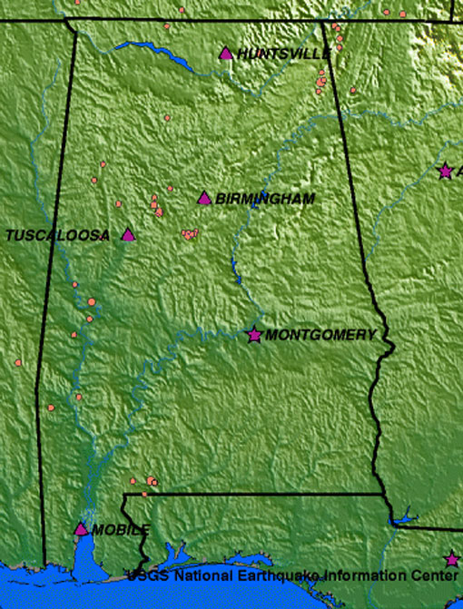
Reported earthquakes in Alabama, 1990-2006. Source: U.S. Geological Survey. |
Those numbers are derived from looking at a hundred years worth of reliable data, Brande notes. So while they can offer a guide as to how many major earthquakes we are likely to see in a given timeframe, they can’t offer any concrete predictions. “We may get three or four in one year, but we might not have another one for three years after that.”
ShakeoutThe potential for injury from falling objects—such as wall-mounted televisions in classrooms—led the Alabama Department of Public Health to join 10 other states this April in a community awareness event called the Great Central U.S. Shakeout. The Shakeout, which is based on a similar program started in California, was held on April 28, 2011, which was the 200th anniversary of the New Madrid earthquake. The drill aimed to teach participants the basics of earthquake safety, which can be boiled down to a three-part action plan: Drop to the ground, take cover (under a sturdy table, for instance), and hang on to that cover until the shaking stops. |
Shake, Rattle, and Fold
In Alabama, earthquake vulnerability has never been a major consideration, primarily because the state has never experienced a devastating earthquake. The Yellowhammer State isn’t likely to be hammered from below in the future, either, says Brande. But that doesn’t mean there is no danger.
“We don’t have the kinds of faults that are likely to cause large earthquakes,” he says. “But we do have faults associated with our mountain ranges and geologic structures, and they do move.” In fact, there are hundreds of tremors in Alabama each year, although most are too small to register on the public consciousness, even if they are recorded on seismologists’ instruments. “It’s the kind of movement that might wake you up at night or shake some bookshelves—not the kind that will bring down buildings,” Brande says.
The last time there was any significant shelf-shaking in Alabama was in 2003, when a quake that measured 4.6 magnitude struck near Fort Payne, a town in the northeastern part of the state known for high ridges and waterfalls associated with the southern end of the Appalachian mountain range. (The largest earthquake in Alabama happened in Irondale, just east of Birmingham, in 1916. It measured 5.1 magnitude and leveled more than a dozen factory chimneys.)
“The Appalachian Mountains are old geologic structures that resulted when this part of the world had a fender bender with Africa and the southern continents some 250 to 500 million years ago,” Brande says. Geologic “fender benders” such as the one Brande refers to occur when large sections of the Earth’s crust, known as plates, crash against one another. These collisions put enormous amounts of pressure on the layers of rock within the crust. And although these layers are extremely strong, they do have a breaking point.
“As plates move, pressure builds up throughout the plate,” Brande says, bending a popsicle stick in his hands to illustrate his point. When the pressure reaches a critical point, the stick in his hands snaps apart. “That’s what happens to rocks,” he says. “The difference is we’re not talking about a few square feet of rock, but rather enormous layers that fold and break apart so that the effect is felt for miles around.”
In the Southeast, the effects of earthquakes on buildings depend largely on the types of structures and where they are located. That’s why some people were rattled awake by the 2003 earthquake in Fort Payne while others were oblivious until they saw the news reports.
Local Motion
The faults, or fracture zones, in Alabama have not produced significant earthquakes since the area was first populated thousands of years ago. But there is a major danger zone a few hundred miles to the northwest. A much larger fault near New Madrid, Missouri, generated a massive quake in the 1800s that caused the mighty Mississippi River to temporarily run backward.
“In the early 19th century, there were multiple shocks in the magnitude 8 range,” Brande says. “So there is the potential for a larger quake there that could affect us here in Alabama, though still not at the level of what we’ve just seen in other parts of the world.”
More Information
Learn more about earthquake safety and regional danger zones at www.shakeout.org.
To see the latest earthquakes recorded by the U.S. Geological Survey in Alabama (and all other U.S. states), click here.